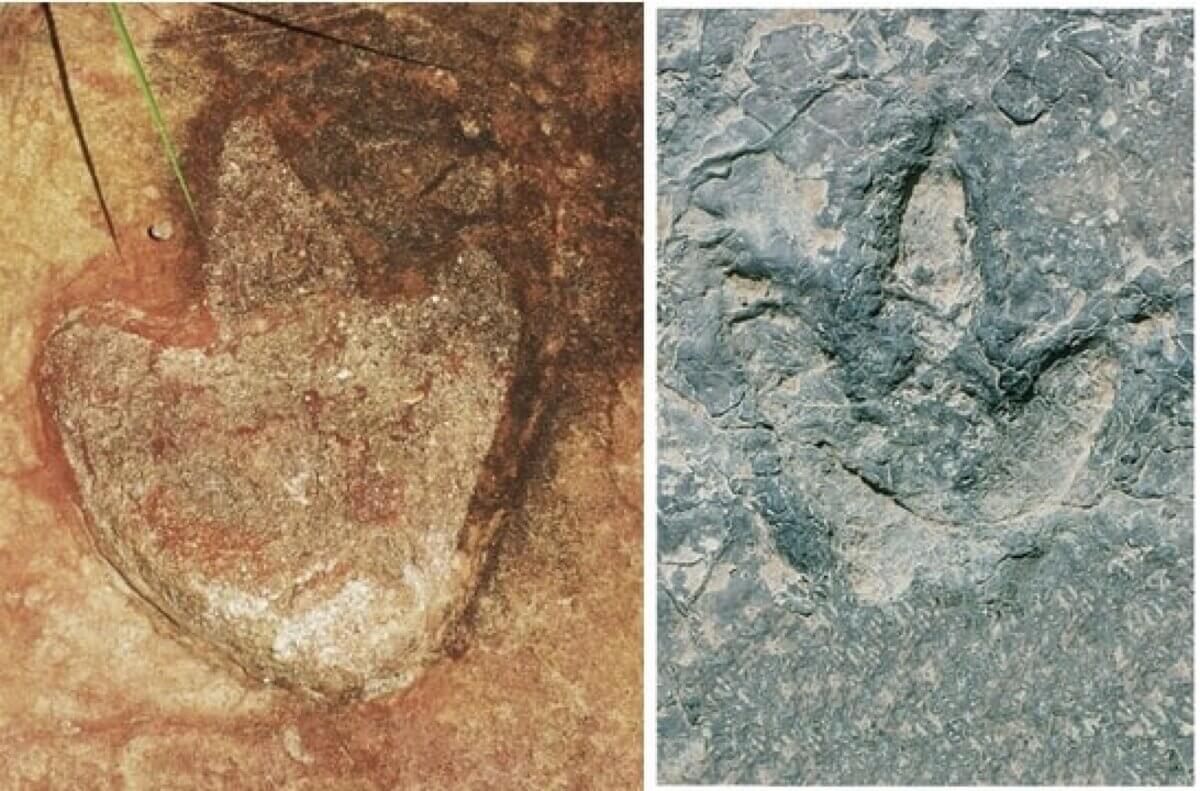
L. Theropod footprint from Sousa Basin, Lower Cretaceous of Northeastern Brazil. Credit: Ismar de Souza Carvalho. R. Theropod tracks from the Koum Basin in Cameroon. (Credit: SMU)
DALLAS — A shocking prehistoric find has pieced together a dinosaur’s journey across two continents, revealing that these giant land masses were once a single supercontinent millions of years ago. Specifically, researchers discovered matching trails of dinosaur footprints in two different regions of the world, as if these prints were broken in half and thrown thousands of miles apart!
An international team of researchers, led by Southern Methodist University paleontologist Louis Jacobs, uncovered this “dinosaur highway” that once connected South America and Africa. This ancient corridor, dubbed the Borborema-Cameroon Dinosaur Dispersal Corridor, allowed dinosaurs to roam freely between what are now two separate continents, leaving behind footprints that have survived for over 120 million years.
“We determined that in terms of age, these footprints were similar,” Jacobs says in a university release. “In their geological and plate tectonic contexts, they were also similar. In terms of their shapes, they are almost identical.”
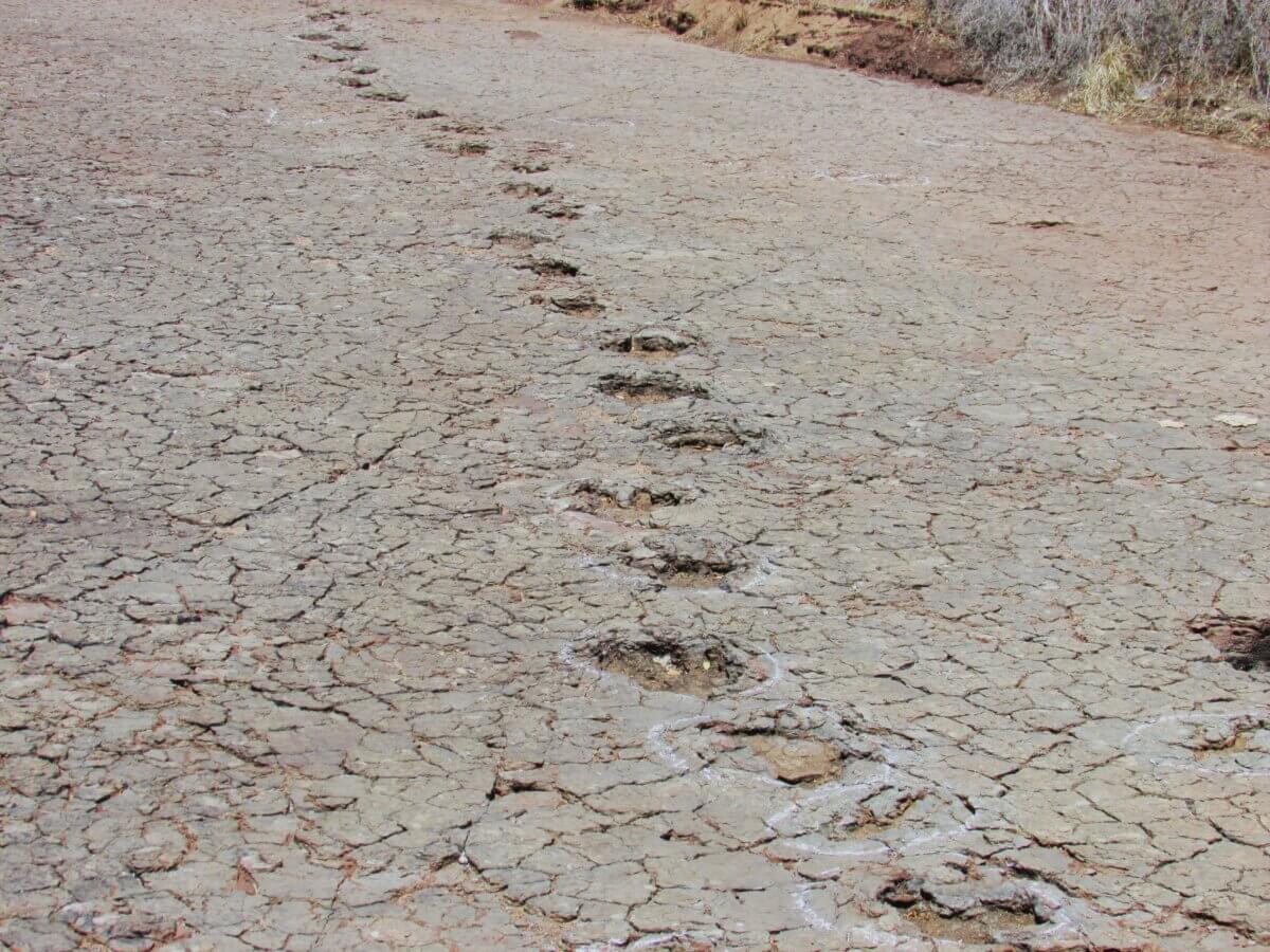
The team discovered more than 260 dinosaur footprints in Brazil and Cameroon, separated today by over 3,700 miles of Atlantic Ocean. These tracks, primarily left by three-toed theropod dinosaurs but also including prints from sauropods and ornithischians, tell a tale of diverse dinosaur communities that once shared this ancient thoroughfare.
So, how did this incredible connection come to be? The story begins with Gondwana, a supercontinent that formed when the larger landmass of Pangea broke apart. As Gondwana itself began to split, a narrow strip of land remained, connecting what would become South America and Africa.
“One of the youngest and narrowest geological connections between Africa and South America was the elbow of northeastern Brazil nestled against what is now the coast of Cameroon along the Gulf of Guinea,” Jacobs explains. “The two continents were continuous along that narrow stretch, so that animals on either side of that connection could potentially move across it.”
According to the team, who published their work in the New Mexico Museum of Natural History & Science Bulletin, this wasn’t just a barren land bridge. Geological evidence suggests it was a lush, tropical environment with seasonal rainfall, rivers, and lakes.
“Rivers flowed and lakes formed in the basins,” Jacobs continues. “Plants fed the herbivores and supported a food chain. Muddy sediments left by the rivers and lakes contain dinosaur footprints, including those of meat-eaters, documenting that these river valleys could provide specific avenues for life to travel across the continents 120 million years ago.”
As the continents continued to separate, magma from the Earth’s mantle rose to fill the widening gap, creating a new oceanic crust. The South Atlantic Ocean gradually filled this void, submerging the dinosaur highway beneath its waves around 120 million years ago.
This discovery isn’t just about dinosaurs – it’s a window into a lost world and a reminder of how dramatically our planet has changed over millions of years. The Borborema-Cameroon Dinosaur Dispersal Corridor helps explain similarities in ancient plant and animal life between South America and Africa, offering new insights into the evolution and distribution of species across these continents.
As we piece together this prehistoric puzzle, we gain a deeper understanding of Earth’s dynamic history and the incredible journeys that shaped life as we know it today. The dinosaur highway may be long gone, but its legacy lives on in the rocks beneath our feet and the shared natural history of two distant continents.
Paper Summary
Methodology
To uncover this ancient corridor, scientists combined several lines of evidence:
- Fossil footprints: They compared dinosaur tracks found in Brazil and Cameroon, noting similarities in shape, size, and arrangement.
- Geology: They examined the rock layers where the footprints were found, determining their age and formation conditions.
- Plate tectonics: Using models of how continents moved over time, they reconstructed the ancient geography of the region.
- Climate models: They used computer simulations to estimate ancient rainfall patterns and vegetation in the corridor area.
Key Results
The study found that dinosaur footprints in Brazil and Cameroon are strikingly similar and date to the same time period (about 130-120 million years ago). The rock formations containing these footprints were once part of a continuous land area.
Additionally, the corridor likely had a tropical climate with seasonal rainfall, supporting diverse plant and animal life. The land bridge disappeared around 120 million years ago as the Atlantic Ocean fully formed.
Study Limitations
Only a few locations with dinosaur tracks have been studied in detail, particularly in Cameroon. The exact duration and timing of the corridor’s existence are still somewhat uncertain. Most evidence comes from footprints, with few actual dinosaur bones found in the corridor region.
Discussion & Takeaways
The study suggests that the corridor played a crucial role in the distribution of ancient life between South America and Africa. Understanding this ancient connection helps explain similarities in fossil plants and animals found on both continents.
The research also highlights the importance of combining different scientific disciplines (geology, paleontology, climatology) to reconstruct ancient environments. This work provides a framework for future studies on the biogeography and evolution of ancient life in the region.
Funding & Disclosures
The research was supported by several institutions, including the Institut de Recherches Géologiques et Minières (Cameroon), the Peabody Museum of Archaeology and Ethnology, the National Geographic Society, and the Collège de France. The authors declared no conflicts of interest in conducting this study.


